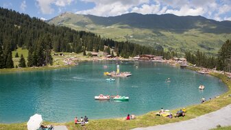
On first-name terms with the mountains of Tyrol
Hiking in Serfaus-Fiss-Ladis
Are you familiar with this situation? You put one foot in front of the other and you keep going higher and further. You feel your thighs and calves with every step. And the scenic views of the surrounding mountains are so incredibly beautiful that you can’t take your eyes off them. A deep breath and your lungs fill with fresh, crisp mountain air. And then, finally! Between 1,200 and 3,000 metres above sea level, you start to feel the “summit tingle”! That’s how you know you’ve made it to the hiking resort of Serfaus-Fiss-Ladis.
Mountain sports recommendations of the "Alpenverein Österreich" for summer
In general there are no restrictions on the hiking and bike trails. If you encounter other hikers or bikers, please keep a safe distance of at least 1 metre. So you protect yourself and others. The Verband alpiner Vereine für Österreich (VAVÖ, austrian alpine association) has developed recommendations for the practice of alpine sports in COVID-19 times:
1. Reduce risk-taking
Stay below the personal performance limit during alpine activities. Consider the corona-related risks and difficulties in rescue operations, as well as the additional burden on the hospitals. More than ever, the rule is: only healthy in the mountains!
2. Keep a distance of at least 1 metre
Wear a face mask to protect mouth and nose if the minimum distance of 1 metre must be exceeded. Certain mountain sports activities (e.g. mountain biking) may also require larger distances.
3. Mountain sports only in small groups
The actual number of people depends on the respective mountain sport. There is an upper limit of 10 people. Keep in mind that as group size increases, it will be more difficult to keep your distance! Avoid high-traffic tours and places.
4. Avoid habitual mountain rituals
For example, shaking hands, hugs, summit kiss, offering drinking bottles to others, etc.
5. Take mouth-nose protection and disinfectants with you
In addition to the general emergency equipment, mouth-and-nose protection and disinfectants should be kept in the backpack.
6. In an emergency, as usual ...
... act as a first aider according to the generally applicable first aid guidelines and additionally use mouth-and-nose mask.
Source: www.alpenverein.at
Hiking variety for all ages in Serfaus-Fiss-Ladis
There are 500 kilometres of hiking trails at the holiday resort of Serfaus-Fiss-Ladis. Lush green pastures, harsh rock formations and well-developed hiking trails are waiting for you to explore them. Every altitude has its very own characteristics. Above 2,000 metres above sea level, you’ll feel the prickling in the air. On the Panorama Enjoyment Trail, there’s a Feel-good Stop with an incredible view of the mountains every couple of metres. Up on mountain giants like the Furgler, summit crosses await the most ambitious of hikers. And if you’ve made it – you can take your shoes off and pose barefoot for the perfect photo of the summit cross!
Kids need variety, action and entertainment while hiking – otherwise they might get bored. So, how about a hiking tour on one of the many themed family trails or through children’s book author Thomas Brezina’s Adventure Mountains? Find out more about the story of the giant called Wode or the haunted pirate ship!
By the way: A lot of the trails are accessible and suitable for baby buggies. And in case you need help getting on the cable car, our staff will be happy to assist you!
The hiking resort of Serfaus-Fiss-Ladis
-
More than 500 kilometres of hiking trails for all ages
-
A large number of opportunities for a break at a mountain hut or restaurant
-
Numerous hiking routes for everyone from 0 to 99 years
-
11 cable cars and lifts that take you up to mountain joy
Our hiking medals
Whether you hike in the villages independently or in a group with a guide, you can collect hiking medals! To do so, you’ll need the hiking pass, which you can pick up for a nominal fee at the information offices. Signs with symbols and a punch are located to the respective hiking destinations. The signs indicate where in the hiking pass the symbols can be punched. Depending on the number of points hiked, you will receive one of our hiking medals (bronze, silver or gold) free of charge.
Psst! Little hikeres, listen up
Collect only 20 points and get the cool Murmli & Berta hiking pin! That’s how every hike becomes a true adventure for the whole family!
Huts and hosts in Serfaus-Fiss-Ladis
During every hike, the right kind of “fuel” is essential. How great that there are plenty of cordial hosts in Serfaus-Fiss-Ladis who are happy to welcome hungry hikers and treat them to all kinds of delicacies.
Experience Tyrolean hospitality and stop by at the many mountain huts and restaurants in the Tyrolean Oberland!
Route tips for mountaineers
Whether you are a pleasure hiker or a demanding mountain climber, whether you are a small or large explorer of nature - the Serfaus-Fiss-Ladis hiking region offers the right tour for everyone. Moments full of bliss and fantastic views included.
kind of sport | name | level of difficulty | length/duration | altitude | |||
---|---|---|---|---|---|---|---|
Königsleitheweg trail (Leithe Wirt) | category: Hiking tour, Thematic route, easy hiking trail | Königsleitheweg trail (Leithe Wirt) | level of difficulty: easy | length/duration: 1.53km/0.75h |
|
||
Schöngampalm – Brunnenjoch via Urgtal valley trail - Fisser Joch | category: Hiking tour, mid-grade / red hiking trail | Schöngampalm – Brunnenjoch via Urgtal valley trail - Fisser Joch | level of difficulty: medium | length/duration: 9.74km/3h |
|
||
Matinesweg trail - Weg der Verliebten (Lovers' Lane) | category: Hiking tour, Thematic route, easy hiking trail | Matinesweg trail - Weg der Verliebten (Lovers' Lane) | level of difficulty: medium | length/duration: 2.73km/1.5h |
|
||
Six Senses - Experience Trail | category: Hiking tour, Thematic route, easy hiking trail | Six Senses - Experience Trail | level of difficulty: easy | length/duration: 6.51km/4h |
|
||
Waalweg (Ditch Trail to Leithe Wirt) | category: Hiking tour, Thematic route, easy hiking trail | Waalweg (Ditch Trail to Leithe Wirt) | level of difficulty: easy | length/duration: 5.09km/1.5h |
|
||
Wiesenweg trail to Ladis | category: Hiking tour, easy hiking trail | Wiesenweg trail to Ladis | level of difficulty: easy | length/duration: 3.15km/1h |
|
||
Fiss – Klobenstein – Langenweg trail – Wiesenweg trail – Fiss | category: Hiking tour, easy hiking trail | Fiss – Klobenstein – Langenweg trail – Wiesenweg trail – Fiss | level of difficulty: easy | length/duration: 3.6km/1.5h |
|
||
Waalweg trail to Möseralm | category: Hiking tour, easy hiking trail | Waalweg trail to Möseralm | level of difficulty: easy | length/duration: 2.76km/1h |
|
||
Waalweg trail to the Kuhalm | category: Hiking tour, easy hiking trail | Waalweg trail to the Kuhalm | level of difficulty: easy | length/duration: 2.55km/1h |
|
||
Genussweg trail Obladis – Neuegg – Wodeturm tower | category: Hiking tour, easy hiking trail | Genussweg trail Obladis – Neuegg – Wodeturm tower | level of difficulty: easy | length/duration: 5.75km/2h |
|
Guided tours with nationally certified mountain guides in Tyrol Austria
Nationally certified mountain guides offer a varied hiking programme from June to October so you can reach the most beautiful and worth seeing places in the region. The tours are planned for hikers with some fitness to be easily managed without special knowledge or skills.
The hiking tours will be published in the weekly programmes (obtainable in all of our tourist offices).
Registration takes place in the tourist offices or directly at the mountain guides or the alpine schools.
Max Tschuggmall |
Alpinschule Fiss-Ladis |
Alpinschule Serfaus Kurt Klinec |
certified mountain and ski guide | certified mountain and ski guide | certified mountain, canyoning and ski guide |
Darreweg 20 6534 Serfaus |
Obere Dorfstraße 36 6533 Fiss |
Im Schilti 1 6534 Serfaus |
Tel. +43/5476/6387 | Tel. +43/5476/6674 | Tel. +43/676/842927169 |
info@dorfblick-serfaus.at | info@alpinschule-fiss.at | kurt@bergaktiv.com |
www.dorfblick-serfaus.at | www.alpinschule-fiss.at | www.bergaktiv.com |
SOS-GEO-Location
Mountain hiking is usually a pretty safe sport and emergency cases are highly rare. But still, you can not preclude happenings such as sudden health problems or getting into bad weather or thunder storms, where you might need immidiate help.
The SOS-system for mountain hikers in Serfaus-Fiss-Ladis rests on two columns. Column number one is the hiking map, which you can find inside of the hiking guide. In this map you will find all important signposts with the related numbers. The second column is the SOS-signpost in the terrain itself, on which emergency signs got affixed this spring.
The whole region contains about 500 of these signs, which are provided with green-white labels. These signs show the number of the signposts, the telephone number of the mountain rescue service and the telephone number of the international rescue service, the map datum, the GPScoordinates and the current height above the sea level.
If an emergency situation appears, you can dial the emergency number with your cellphone and give out information about the GPS-coordinates and the map datum (for example: WGS 84). This allows them to find your current position with centimetre precision and the rescue service does not loose any time by searching for an inaccurate declared position.
Nordic Walking
Nordic Walking is a kind of all over body fitness programme. Stretching exercises, invigoration exercises and a wide range of Nordic Walking techniques are performed with special Nordic Walking poles made of carbon. When correctly carried out, Nordic Walking improves the body’s fitness levels and aerobic stamina (cardiovascular system). It also helps you to lose weight. The careful use of Nordic Walking poles strengthens both the legs and the upper part of the body. Joints are relieved and the area around the shoulders and back of the neck becomes more flexible.